 Chinese
 German
 Spanish
 Japanese
 Korean

Choosing an INS device for mobile mapping is a crucial decision. The right hardware can dramatically improve the quality of your final survey, and the ease with which you gather the data – even in challenging environments. But how do you make that decision?
In this blog, we’re looking at how to choose between different GNSS-aided inertial navigation systems, or GNSS/INS. We’re also offering a comparison of the OXTS GNSS/INS devices best-suited for mobile mapping.
Why the choice of INS device for mobile mapping matters
Although every GNSS/INS fundamentally does the same thing, there are a range of characteristics that make a particular device better suited to one application versus another.
Accuracy requirements
This will be top of mind for every mobile mapper. You need your localisation solution to deliver the right level of position accuracy for your survey data – without that, the survey won’t do its job.
Within the realm of accuracy, there are a few factors to consider:
- The quality of the hardware: the components used are obviously a major determination of accuracy.
- The build quality: with the right build, careful calibrations, and clever algorithms, it’s possible to get more accuracy out of more economical parts, giving you the right accuracy without a premium price tag.
- Sensor alignment: even slight misalignment between your surveying sensor and your GNSS/INS can result in poorer results. For LiDAR point clouds, for instance, misalignment of a few tenths of a degree between the LiDAR and the GNSS/INS can result in blurring and ‘double vision’ where objects appear twice in the point cloud.
Platform size and payload
If you’re mobile mapping using a small-scale platform, the size of your GNSS/INS will matter. For aerial platforms such as quad-copter drones, the weight and power requirements of the GNSS/INS will have a direct impact on the drone’s flight time, potentially limiting the speed with which you can survey an area.
They key is balancing the SWaP constraints (size, weight and power) with the performance of the unit, to ensure you get the best performance possible.
GNSS environment challenges
By itself, GNSS performs best under open skies. But surveyors and mobile mappers often need to map areas where GNSS signal is weaker, including:
- Urban environments where tall buildings block and reflect GNSS signals, causing errors.
- Spaces where there is no direct line of sight to the sky, such as indoors or under tree canopies in a forest.
- Underground environments where GNSS signal is completely blocked.
It’s important to know how your GNSS/INS compensates for these challenges – if it does at all. If it doesn’t, you will need to spend time and effort integrating additional sensor data into your payload in order to create a robust enough mobile mapping solution.
Overview of OXTS INS devices for mobile mapping
Our GNSS/INS devices all work roughly the same, and all offer the level of accuracy needed for mobile mapping. But there are a few differences in terms of form factor, performance, and size that mean one might be better suited to your use case than others.
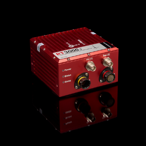
RT3000 v4
Performance: Premium
The RT3000 v4 is our flagship GNSS/INS. It delivers position accuracy to 1 cm, has a wide range of connectivity options, and low-dynamics warmup so you can get surveying faster. A DO-160-approved model is also available for aerial mapping.
Notable specifications:
- Position: 0.01 m
- Heading: 0.04°
- Pitch/roll: 0.01°
- Altitude: 0.012 m
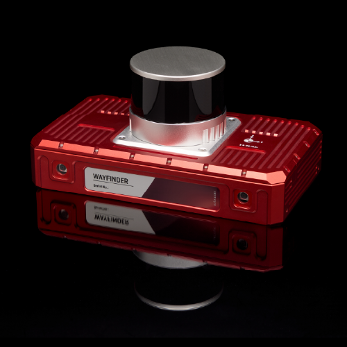
WayFinder
Performance: Premium
WayFinder is our GNSS-denied localisation unit, offering centimetre-level accuracy even underground. It features an integrated LiDAR, meaning mobile mappers can use it for GNSS-denied localisation with minimal integration effort.
Notable specifications:
- Position: 0.01 m
- Heading: 0.05°
- Pitch/roll: 0.02°
- GNSS-denied position: 0.03 m
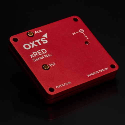
xRED
Performance: Premium
xRED is a board set INS designed for integrators. Ideal for SWaP-constrained environments and custom payloads, it delivers almost the same performance as the RT3000 v4, despite being a fraction of the size.
Notable specifications:
- Position: 0.01 m
- Heading: 0.05°
- Pitch/roll: 0.02°
- Mass: 39g
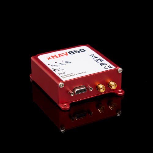
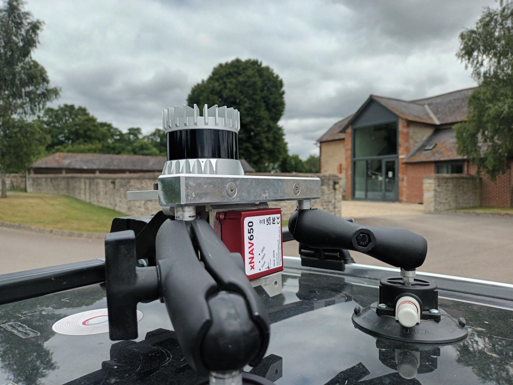
xNAV650
Performance: Standard
The xNAV650 is ideal for applications where battery life and weight are key considerations. It delivers survey-grade accuracy while being light enough to mount on a drone with minimal impact on mission time.
Notable specifications:
- Position: 0.02 m
- Heading: 0.1°
- Pitch/roll: 0.05°
- Altitude: 0.03 m
How to choose the right system based on your application
Road and rail mapping
Road and rail mapping generally cover large distances – hundreds of square miles, potentially. That means you need a localisation solution that drifts minimally over time. Protecting position drift can be done using additional sensors, but can also be improved by the quality of the Kalman Filter inside the GNSS/INS (the algorithm responsible for detecting and rejecting erroneous data).
Rail mapping is a particularly challenging use case for some providers due to the way trains move. Part of the Kalman Filter in a GNSS/INS is a data model that constrains the outputs to match the movement of the vehicle. For instance, for a car that model would automatically count lateral movement without any forward or backwards movement as erroneous, because cars cannot move sideways without moving forwards or backwards. Trains move in unique ways that need accounting for to accurately capture their location.
Size and weight aren’t generally a consideration for either road or rail mapping as the payload is mounted on a car or a train – but cost can be, if you are looking to outfit a fleet of vehicles for mapping. Accuracy is also important – though it’s not always a case of ‘more is better’. We have a client, for instance, using road-based mobile mapping to identify gas leaks. They only need accuracy to within a metre – meaning they can use a more economical unit such as the xNAV650. Other applications, however, will require centimetre-level accuracy, requiring a more specialised unit.
Another consideration is environment. Both roads and tracks often go through long tunnels, and areas where GNSS signal is limited. You will need effective tools to protect position accuracy in these environments, such as our gx/ix tight-coupling technology, or multi-sensor fusion (either in real time or in post process).
Our recommendation:
- RT3000 v4
- WayFinder
- xNAV650
Read how BeeXact were able to map the whole of the Italy’s road network using an RT3000 v4
Aerial Mapping
Aerial mapping projects, where the vehicle is a large-scale aircraft, require accuracy and reliability more than anything. Surveying points thousands of feet below you means you need the most accurate position data possible to ensure the final survey dataset is clear. And if your system is unreliable, you may find yourself having to re-survey areas if your system fails – a costly endeavour.
Size and weight aren’t a challenge in this use case, and neither is GNSS-denied navigation, as you can count on strong GNSS signal. However, in certain defence applications, contested airspace may be subject to GNSS jamming; in these instances the ability to integrate additional sensors such as airspeed sensors can help you preserve accuracy.
A GNSS/INS being used in an aerospace environment will also need to be protected against a few different forms of interference. Those include electromagnetic interference, as well as extreme temperatures, changes in pressure, water, and even lightning strikes. The DO-160 standards have been designed to rate a device’s protection against these phenomena – and the RT3000 v4 DO-160 has passed the most DO-160 tests of any MEMS GNSS/INS on the market, making it an ideal aerial mapping solution.
Our recommendation:
RT3000 v4 DO-160
UAV and robotics mapping
For UAVs and robotics, SWaP constraints are the foremost consideration – specifically, balancing those with the accuracy you need. A unit that’s too heavy will drain the battery faster, limiting mission time.
Indoor localisation capabilities are also likely to be important. Robots and drones are often used to map hazardous spaces that are unsafe for humans, or places that are inaccessible to people and larger vehicles. Those spaces are often indoors, or underground, where GNSS signal is non-existent. Whether your GNSS-denied localisation capabilities are real-time, or post process, is likely down to your budget, SWaP constraints, and use case – a land-based robot might be able to mount WayFinder with ease, but a drone might need to use an xNAV650 with post-processed LiDAR inertial odometry (LIO) instead. Both offer the same levels of accuracy – just one does it in real time, the other in post process.
Our recommendation:
- xRED
- xNAV650
- WayFinder
GNSS-denied environments
GNSS-denied environments require a localisation solution that uses alternative methods to calculate position. SLAM (simultaneous localisation and mapping) is a common method used in mobile mapping, but it struggles over longer distances and isn’t effective at transitioning between indoor and outdoor environments.
Alternatively, multi-sensor fusion offers a way to provide robust localisation when GNSS signal is blocked. It can help to retain accuracy over longer distances, and can transition back to GNSS when required. It can be more technically challenging to implement (though solutions like WayFinder make it much easier), but the benefits of multi-sensor fusion can be well worth the effort.
Compact platform constraints
We’ve already mentioned the challenge of platform constraints; maximising accuracy while keeping power used, size and weight to a minimum is vital in various applications.
OXTS offers a number of options for SWaP-constrained platforms. The xNAV (and its sister product the AV200) are both small units that have been successfully mounted onto drones before. The xRED is even smaller, though unhoused – meaning it’s best suited to projects where you’re integrating the payload into a larger unit.
Final recommendations
The right GNSS/INS for your mobile mapping needs is dependent on a number of factors, including where you are surveying, what platform you are surveying from, and the accuracy you need.
The last piece of the puzzle is the company who makes the device you’re using. What are they like to work with? Is their support strong? How do they calibrate their devices during its lifetime? Are they able to help you with custom projects if needed? These touches can make the difference between a project that’s a roaring success, and one that’s highly pressured and difficult.
At OXTS we do our best work in partnership with our customers. Alongside global support services, we’ve worked with our customers to solve unique challenges that lead us to create new features, push our technology further, and build a wealth of in-house expertise in mobile mapping.
Download the RT3000 v4 Datasheet
Learn more about the specifications you can expect from our flagship INS for mobile mapping – the RT3000 v4


