 Chinese
 German
 Spanish
 Japanese
 Korean

Inertial Navigation Systems – why are they essential for mobile mapping with LiDAR?
This article was written by Iain Clarke, Senior Product Engineer at OXTS in collaboration with LiDAR News. Iain is an expert in inertial navigation, sensor fusion, and advanced localisation technologies.
An introduction to inertial navigation systems
What is an INS?
Inertial Navigation Systems (INS) have become an essential part of many modern positioning workflows, especially when traditional GNSS falls short. This section explores why INS is a critical companion to technologies like LiDAR.
An INS is a device that measures position and motion using inertial sensors and sophisticated algorithms. At the most basic level, an INS uses a technique known as dead reckoning to continuously estimate how an object has moved based on its last known location and the integration of acceleration and angular rate measurements since then. However, there are small errors in these inertial measurements, which grow when integrated to calculate velocities, and compound further when integrated again to calculate position. In order to constrain the error growth, additional sensors are often combined with the Inertial Measurement Unit (IMU). One of the most commonly used aiding sensors is GNSS.

Why INS matters when mobile mapping with LiDAR
LiDAR’s primary advantage lies in its ability to rapidly capture high-density, high-accuracy spatial data. But when a LiDAR scanner is mounted on a moving platform, such as a vehicle or aircraft, the accuracy of that data becomes dependent on how accurately the platform’s position and orientation are updated. That’s where high-rate inertial navigation comes in.
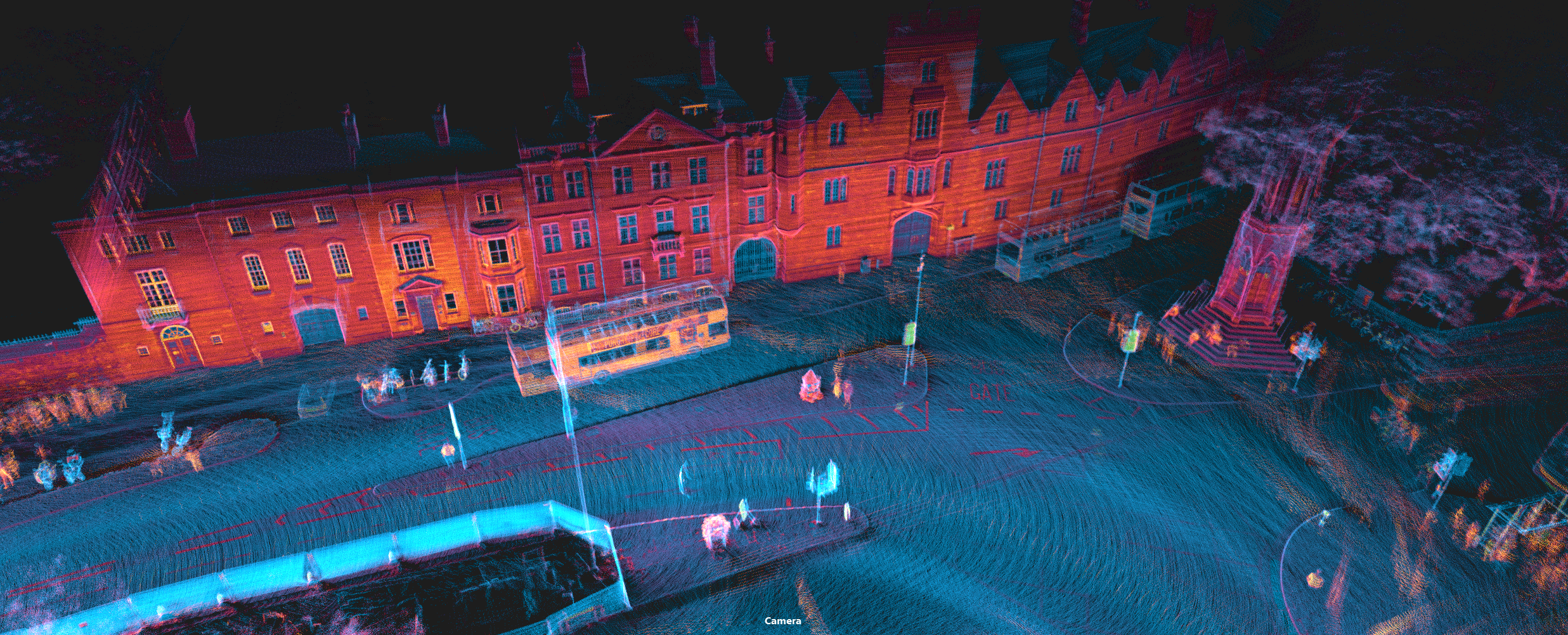
High-end INS, like the OXTS RT3000 v4, can deliver navigation data at rates of 100 Hz (100 times per second) or even 250 Hz, far outpacing typical GNSS-only solutions, which are often limited by lower update frequencies and signal dropouts in obstructed environments. The high-frequency, low-latency data stream in an INS is an excellent tool for ensuring accuracy when mobile mapping with LiDAR, where deviations in position or orientation can introduce significant errors into point cloud data. SLAM provides an alternative method for determining position and orientation, but SLAM-only systems—without the support of an INS—produce lower-quality point clouds with current techniques.
How does INS work?
To understand how an INS works, it’s important to first examine the components at its core. An INS relies on precise motion sensing from accelerometers and gyroscopes, which together form an Inertial Measurement Unit (IMU). IMU data is processed by sophisticated algorithms. An INS combines raw IMU data with sophisticated algorithms to calculate detailed navigation data (specific measurements explained below).
Accelerometers and Gyroscopes
Accelerometers and gyroscopes are the sensor components that make up an IMU. Accelerometers measure linear accelerations and gyroscopes measure angular rates, or rotational velocity. An IMU typically consists of one of each of these sensors in each measurement axis (x, y, z), leading to the term “6-axis” sensor.
There are various technologies used for creating different grades of IMU, but the most widely used is MEMS (microelectromechanical systems). This technology works by using tiny masses mounted on springs in silicon. When motion occurs, the mass moves and causes a change in capacitance between the mass and electrodes, which is converted to a digital electrical signal to give a measurement of the motion.
Navigation Data Output
OXTS INS output navigation data at 100 Hz as standard, with a high-rate 250 Hz option available. All data is automatically logged to internal storage and can be output in real-time with very low latency. The navigation data includes time, position, velocity, orientation, acceleration, and angular rate in a variety of different reference frames and coordinate systems. Alongside these, there is a host of additional information such as accuracy estimates, quality indicators, status information, and some more niche measurements for specific industries, for example jerk, slip angle, and undulation.
I
Expanding Applications of INS
As demand for precise localisation grows across industries like robotics, aerospace, and autonomous systems, INS adoption is accelerating. By complementing or replacing GNSS in signal-limited environments, INS enables accurate, high-frequency positioning and orientation through advanced sensor fusion. This section explores when INS is most critical and how it supports emerging technologies, including LiDAR.
Mobile mapping with LiDAR – when is an INS needed?
Standalone GNSS can provide high accuracy positioning data, but it is obviously reliant on having good satellite signal. It also has a relatively low update rate making it less suitable for more dynamic use cases, and can only provide position and velocity information. The addition of INS technology greatly increases the range of use cases and capabilities. Sensor fusion with the IMU increases the resilience of the outputs meaning it can cope with obstructions or losses to satellite signal. Localisation data is also output at a higher rate, and much more information is available for full 3D pose and dynamics data.

Industries using INS
INS technology has a long history in aerospace, defense, maritime, and surveying applications. In recent years, however, it has seen significant adoption in emerging fields such as automotive testing, robotics, UAVs, and augmented and virtual reality (AR/VR).
Today, some of the most innovative and rapidly advancing projects are those operating in environments where GNSS alone is unreliable or unavailable. These include mobile mapping with LiDAR in urban canyons, tunnels, dense forests, and autonomous systems that must navigate seamlessly between indoor and outdoor settings. In such scenarios, combining INS with complementary sensors like LiDAR and cameras enables sophisticated sensor fusion, delivering higher accuracy, greater resilience, and enhanced operational flexibility.
Inertial navigation systems for LiDAR
The integration of INS with LiDAR is becoming increasingly common, as mobile mapping with LiDAR extends beyond traditional geospatial surveying into fields like automotive testing and autonomous vehicle development. While INS improves the accuracy and reliability of LiDAR-based mapping, LiDAR can also enhance INS performance. The recently released OXTS WayFinder is a prime example—it incorporates a pre-integrated LiDAR sensor and features LiDAR Boost technology, which uses LiDAR data for localisation in GNSS-denied environments, dramatically reducing or even eliminating position drift. This underscores the value of combining complementary technologies—GNSS, INS, and SLAM—to achieve robust and resilient localisation across a wide range of operating conditions.

Advancements in INS
The rapid evolution of INS technology has opened up new frontiers in precision navigation. As hardware becomes smaller, faster, and more affordable—and as sensor fusion techniques become more sophisticated—INS is becoming accessible to a broader range of industries and use cases. This section highlights the key developments, ongoing challenges, and emerging trends that are shaping the future of inertial navigation.
Recent advancements in INS
The development of both IMU and GNSS technology over the years has enabled INSs to become viable in many more industries, not just the realm of aircraft and submarines. RTK capability is almost ubiquitous on GNSS receivers now, bringing centimetre-level positioning to even entry-level systems. And IMUs have gone from big bulky blocks of orthogonally mounted discrete accelerometers and gyroscopes; to miniature chips that incorporate all 6 sensors in a single module. The miniaturisation and cost reduction in these sensors has enabled the development of viable cost-effective systems in emerging industries like autonomy and robotics that have visions of scale, without compromising on the performance.
Current limitations for INS
One of the traditional limitations to INS adoption is the cost. Going back 10 years or so, a lot of the technology was prohibitively expensive, limiting its use to industries like defense and aerospace which had the appropriate budgets. That has changed now with the progression in the technology making it much more viable and scalable in commercial and industrial applications.
Another limitation which is becoming more prevalent in recent years is the requirement to operate in challenging environments including completely GNSS-denied. If GNSS is the only aiding source to constrain the IMU errors in an INS, then without it you either start struggling to maintain useable outputs very quickly, or you have to rely on very expensive and cumbersome IMU technology like fibre-optic or ring-laser gyros.
This is where advanced sensor fusion becomes increasingly important. Instead of relying solely on a more precise IMU to compensate for the absence of GNSS, integrating additional sensors—such as LiDAR or cameras—using a SLAM-like approach can provide robust alternative sources of localisation data for mobile mapping with LiDAR.
Development in INS technology
IMU and GNSS technologies continue to advance, with modern satellite constellations like Galileo offering new signals that improve both accuracy and integrity. Meanwhile, next-generation IMUs—such as those based on silicon photonics and quantum sensing—are on the horizon. However, the most significant progress is likely to come not from pushing the limits of GNSS and IMU alone, but from expanding the scope of sensor fusion to address their limitations and add redundancy. lidar and visual SLAM technologies are now becoming widely accessible across industries. When integrated with INS, these sensors can create more robust, versatile, and capable navigation systems that perform reliably even in GNSS-denied environments.
Autonomy, robotics and high-precision
As autonomy, robotics, and high-precision mapping expand into increasingly complex and varied environments, the need for reliable positioning in GNSS-denied or degraded conditions is growing. While GNSS remains a valuable source of global positioning when available, it cannot be relied upon in tunnels, dense urban areas, forests, or indoors. In response, the industry is shifting toward advanced sensor fusion approaches that integrate IMUs with alternative sensors such as LiDAR, cameras, and odometry. These systems are designed to deliver high-accuracy, high-reliability localisation across all operating environments—ensuring consistent performance regardless of GNSS availability.
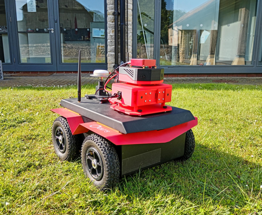
Download the RT3000 v4 Datasheet
The RT3000 v4 can help you to deliver your mobile mapping project accurately, reliably and on-budget. Find out the technical specifications and more key information here.


