 Chinese
 German
 Spanish
 Japanese
 Korean

How does LiDAR work?
How does LiDAR work? This expert-led article is a great place to learn how LiDAR is used. Learn LiDAR basics, and about LiDAR sensors and mapping
If you’ve always wondered “how does LiDAR work?” Then this blog is for you. It explains how LiDAR uses pulses of laser light to measure distances to surrounding objects and turn those measurements into highly accurate 3D spatial data. We also touch on how localisation and LiDAR data make a dream team when it comes to LiDAR mapping and autonomous navigation projects. That combination is one of the reasons LiDAR has become such an important technology in mobile mapping, surveying, robotics, and intelligent vehicles.
Understanding LiDAR is easier when you break it down into a few core ideas: what the sensor is, how each pulse is measured, how a point cloud is created, and how that data is used in mapping and navigation.
LiDAR explained: What is LiDAR sensor technology?
LiDAR is a core technology in a number of fields, including mobile mapping and autonomous navigation. If all you know about LiDAR is that it’s an acronym, or that it involves lasers, then read on. In this blog, we’re explaining what LiDAR is, how it works, and how it’s used.
What is a LiDAR sensor?
A LiDAR sensor is a device that uses LiDAR technology to scan its surroundings. LiDAR stands for Light Detection And Ranging, and has been around since the 1960s, although it is only in the last decade that it has really come into its own.
Depending on the application, a lidar sensor may be mounted on a static platform, a vehicle, a drone, or another mobile system. Some sensors scan in a fixed direction, while others rotate or use more advanced scanning patterns to capture a broader field of view. In all cases, the purpose is the same: to gather reliable spatial data that can be used for analysis, navigation, or mapping.
How does LiDAR work?
LiDAR works exactly the same way as radar, but by sending out pulses of light instead of sound. When a pulse reaches an object, it bounces off that object and returns to the scanner. The scanner detects the returning pulse, calculates how long the pulse took to return, and uses that to calculate how far away the object is.
Because of the shorter wavelength of LiDAR compared to radar and sonar, LiDAR is arguably the best sensor for high-resolution data. That is a major part of why LiDAR is often chosen when detailed surface information is needed. It can capture fine features and subtle changes in shape that are important in both mapping and navigation workflows.
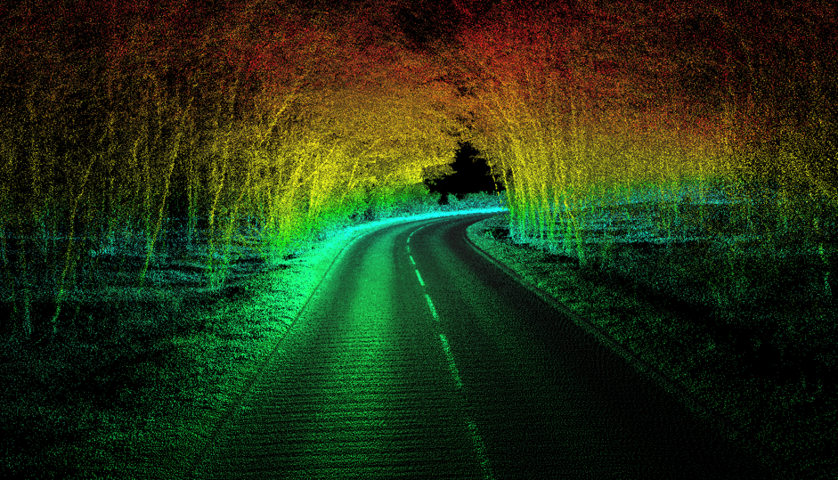
LiDAR scanners typically send out millions of pulses of light in a scan. Each returning pulse is recorded as a point in space; over the course of a scan, a massive collection of points is generated. Those points are referred to as a point cloud. The point cloud is one of the most important outputs of a LiDAR sensor because it forms the basis for later processing, modelling, and interpretation.
Once a point cloud has been created, software is used to process it into more usable outputs. These might include 3D models, terrain representations, measured features, or structured map data.
What is LiDAR used for?
Given its use for range-finding, there are two main uses for LiDAR technology: surveying and mapping, and in navigation.
In surveying and mapping, the LiDAR scanner is attached to a car, drone, plane, or boat, and moves around an area or an object, scanning it. The point cloud this creates is turned into a map of the thing being surveyed, from which accurate distances can be calculated.
Surveying applications can include corridor mapping, infrastructure capture, asset inspection, terrain modelling, and wider geospatial data collection. The exact workflow will vary, but the core principle remains the same: the LiDAR sensor captures geometry at scale and with a high level of detail.
OXTS Pointcloud fly-through – Minster Lovell Ruins
Using LiDAR in autonomous navigation
In navigation, the LiDAR sits in a system of different sensors, scanning the environment around the autonomous platform. The data is used for a variety of applications, including object detection and real-time mapping using algorithms such as SLAM.
In these systems, LiDAR helps the platform understand what is around it and how the environment is changing in real time. That matters for detecting obstacles, identifying features, and supporting safe movement through complex spaces.
For both of these applications, the LiDAR data needs to be paired with localisation data in order to be useful.
LiDAR mapping needs localisation
In surveying, the point cloud generated from a LiDAR needs to be located on the earth; each point has to be given a set of coordinates. That process is known as georeferencing.
Georeferencing is absolutely vital for making point cloud data useful for surveyors. Without it, you can’t use the point cloud to measure distances reliably, or accurately state the position of anything on your survey. And, in order to make georeferencing happen, you need a device that can accurately record the position of the LiDAR scanner throughout its survey. That is normally a GNSS/enhanced inertial navigation system, or GNSS/INS.
OXTS GNSS/INS devices are used by many surveyors for georeferencing their LiDAR data. Working with OXTS gives those surveyors high levels of accuracy in a wide range of environments. Crucially, OXTS has a dedicated tool for combining LiDAR and GNSS/INS data to produce a georeferenced point cloud: OXTS Georeferencer. Georeferencer not only makes georeferencing data quick and easy, but it also includes a boresight calibration tool that precisely aligns the LiDAR and GNSS/INS to produce crystal clear point clouds.
Thanks to a range of clever algorithms and sensor fusion capabilities, OXTS devices specialise in providing accurate data even in areas where satellite signal is poor or nonexistent (for instance, if you were surveying indoors). We’ve also got pre-built integrations with most of the major LiDAR brands, making it easy to integrate our technology into LiDAR mapping payloads.
Localisation also benefits from LiDAR
Just as localisation data is useful for LiDAR mapping, LiDAR data can also help improve localisation data. OXTS has developed LiDAR Boost, which analyses point cloud data from a LiDAR scanner to calculate velocity measurements. Those measurements can be used by the GNSS/INS to improve position accuracy in areas where GNSS signal is nonexistent, such as underground car parks. Since many survey and autonomy payloads already include LiDAR, we’re excited about LiDAR Boost’s potential to improve the quality of navigation data without the need for additional equipment!


