 Chinese
 German
 Spanish
 Japanese
 Korean

The demand for mobile mapping services globally is rising – the market size is projected to reach $89.74 billion by 2030, from $31.78 billion in 2023.
This demand is being driven by a few factors, including advances in mobile mapping technology, falling costs for entry level equipment, and new solutions that reduce the complexity of building and implementing mobile mapping systems. The knock-on effect of this is that the equipment gets into the hands of more people who in turn use it for more unique projects.
In this blog, we’re taking a look at nine mobile mapping applications that we think will be important in the next five years.
1. Smart cities
The rise in IoT devices and the mobile networks to support them means that smart cities are closer to reality than ever before and great use cases for mobile mapping. GIS mapping will be vital to these smart cities, as many of the services will rely on the system knowing the position of each component.
Consider, for instance, an example where a cyclist is injured in a fall. Their smartwatch signals that they have had a fall, and monitors their vitals. As it looks likely they need medical assistance, the watch automatically contacts the emergency services. An ambulance is dispatched, with the route to the pedestrian automatically calculated. At the same time, traffic lights along the route hold traffic to enable the ambulance to respond as quickly as possible.
In that example, an accurate map of the city, with the position of the ambulance station and all the traffic lights, is vital for the system to function as expected.
This is an area where emerging mobile mapping technologies are crucial. It has always been challenging to get accurate position data in cities due to the large volume of tall metal buildings (a phenomenon known as urban canyons), but new technologies such as LiDAR Boost make it possible to get accurate position data in cities.
Learn more: How LiDAR Boost supports GNSS-denied navigation
2. Autonomous vehicle maps
The ability to create accurate maps of urban spaces also opens up possibilities for autonomous vehicles. Any autonomous vehicle, from a robotaxi to an autonomous mining truck, needs some form of map to successfully navigate. Creating those maps relies on surveys, such as mobile LiDAR, that can operate to a high level of accuracy in any environment.
Vehicle OEMs are the main consumers of these maps. Some will try to generate the maps themselves, but it’s also likely that a thriving market of service providers will grow up providing maps to vehicle manufacturers.
In some cases, these maps will require accurate positioning data even when there is no GNSS signal at all. Autonomous mining is the main example to think of here – generating accurate maps for autonomous mining trucks to navigate from. Accurately mapping mines in a way that can be used by an autonomous navigation system is an ideal use case for our LiDAR Boost technology, which uses mobile LiDAR to help estimate position.
3. Asset management
Asset managers with a large and distributed number of assets to manage can benefit from mobile mapping technology, especially if their real estate is dispersed over a large area. Tools such as mobile LiDAR can be used to help visualise a company’s assets on a map, allowing decision makers to get a broader sense of their asset and any associated challenges – especially those caused by geography, such as flood risk or subsidence.
Mobile mapping is also particularly useful for managing infrastructure assets such as cable networks and pipework. Combined with sensors such as ground penetrating radar, mobile mapping can help a company track its infrastructure down to the centimetre, making activities such as predictive maintenance more efficient.
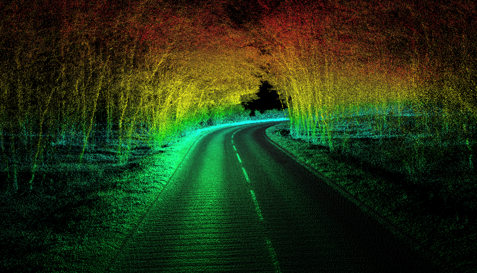
4. Road surveying
A major mobile LiDAR use case is surveying road networks. The data can be put to a number of uses:
- The maps can be used by autonomous vehicles or navigation apps.
- By fusing the map data with data about the condition of the roads, predictive maintenance can be undertaken on roads to reduce disruptions to drivers, improve road worker safety, and minimise road closures.
- The data can even be used to inform road design to improve safety, like our customer Panpro has done.
When it comes to road mapping, it’s vital that your mobile mapping setup is able to compensate for drift over time, keeping it accurate even over hundreds of miles. And, of course, if the road goes through tunnels, or into cities where GNSS signal is limited, you’ll need a setup that can compensate for these challenges.
The ability to output data to an external data logger is also vital, given the volume of data you will collect (especially if you are conducting a LiDAR scan).
5. Rail mapping
Rail mapping has similar applications and challenges to road mapping, with a few unique angles. In rail mapping, depot/platform management and predictive maintenance of tracks, tunnels and bridges are a major benefits rail operators can realise by getting accurate mapping data – provided they can then get location data from the trains themselves in real time. Mounting a mobile mapping payload onto a train, allows it to collect data across its route, enabling engineers to keep a close eye on the condition of the line and its surrounding infrastructure on a continuous basis. Rail worker safety is also improved due to a reduced need for engineers to work directly on the tracks.
The challenge with rail mapping is in the vehicle model used. In every mobile mapping setup is an algorithm known as a Kalman Filter, which identifies and helps remove erroneous data from the overall position calculation. That includes a set of rules based on the vehicle the payload is attached to. For instance, when mapping in a car, the Kalman Filter contains rules that mean any data which implies the vehicle has moved sideways without going forwards or backwards must be inaccurate, because cars cannot move that way. The challenge is that trains move differently from cars.
Trains accelerate very slowly, but reach very high top speeds. They also turn differently to cars, since they have two bogeys with both rotate, rather than a fixed rear axle and moving front axle. Crucially, it’s also not possible to drive a train in a figure of eight, which is a common manoeuvre required to initialise the IMU in a mobile mapping payload.
OXTS is working with a few different partners to develop a rail mapping solution that solves these challenges to deliver precision localisation data for railways. If you’re interested in working on this challenge with us, please get in touch.
6. Geographic surveys
Perhaps the simplest use of mobile mapping is to build a map. Geographic surveying, or cartography, is a major use case for mobile mapping, as it offers cartographers the opportunity to create maps that are more detailed and accurate than ever before.
Geographic surveyors face all the challenges of other mobile mappers – operating in environments where GNSS signal is limited, and maintaining accuracy over long distances, to name a few. But they also face unique challenges of scale. The Ordnance Survey, for example, needed to outfit an entire fleet of vehicles with mobile LiDAR to achieve their aims; this required a solution that was scalable both commercially and from a data processing perspective.
Read more about our work with Ordnance Survey
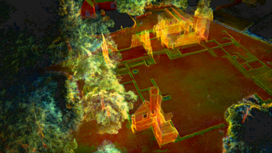
7. Archaeological surveys
From building maps of the ground, to finding out what’s buried in the ground – archaeological surveys are another area where mobile mapping technology is facilitating exciting advances. In particular, aerial LiDAR surveys are revealing a world of discoveries that wouldn’t be possible from the ground; armed with this data, archaeologists can choose dig sites with a far greater chance of discovering new data and artefacts than ever before. Even the ability to view buried ‘maps’ of ancient civilisations is leading to new discoveries about the complexity and scale of ancient civilisations.
Obviously, the key with mobile mapping for archaeology is the accuracy of the fusion between the two sensors. LiDAR sensors produce millions of data points, all of which need to be given an accurate position in order to deliver maximum value. Mobile mappers building payloads for this sort of work would benefit from tools such as OXTS Georeferencer, that make the process of combining LiDAR and position data far easier and more accurate than ever before.
Form factor is also important when thinking about mobile mapping for archaeology. Archaeological surveys can be conducted from the air, the road, or even on foot. Positioning systems that can function in multiple environments, therefore, will offer far more value. The OXTS xNAV650, for instance, can be mounted on a car, a backpack, a plane or a drone with equal ease.
Learn more about OXTS Georeferencer
8. Digital construction
One of the greatest challenges in construction projects is ensuring that projects happen on time and budget – often due to mismatches between the plan, and what happens on the ground. GIS mapping of construction sites helps firms manage these issues in two ways. First, an accurate survey of the ground before construction begins can uncover any issues that might affect the construction process, that need to be accounted for by an architect.
Secondly, as construction takes place, regular surveys can be conducted of the site and compared with the plans to ensure they match. If the plans have been uploaded into a building information modelling (BIM) system, this entire process can be managed digitally.
As an added bonus, an accurate map of a building at completion can be converted into a digital twin of the building itself. This twin can show building managers real-time information about the building, including output from any sensors integrated into the building, energy consumption information, even whether any lightbulbs need replacing or which meeting rooms are free. That information can be used for predictive maintenance, optimising running costs, and ensuring the building is used effectively throughout its life.
When it comes to mapping construction sites, the main challenge is GNSS signal. With lots of bare metal and indoor spaces, GNSS signal cannot be relied upon for accurate location data – so solutions such as SLAM or real-time sensor fusion should be used instead.
9. Structural surveys
Existing structures often need surveying in order to assess whether repairs are required, or to evaluate the potential of the structure for repurposing. Mobile mapping – especially drone mapping – is an ideal tool for these applications. Drones are usually able to navigate into spaces that are too dangerous or inaccessible to humans, while delivering highly accurate data.
As with the digital construction example, accuracy in challenging environments is the major mobile mapping challenge here. If you are identifying weaknesses in a structure, for instance, you need to be able to locate them accurately in order to be sure repairs do their job. Additionally, if drones are being used then the size, weight and power (SWaP) ratios of your payload need to be considered. Simply put, you need the most accurate system you can get, in a small, lightweight form factor that has enough power to complete a mission in a single charge.
In all use cases for mobile mapping versatility and resilience are key
Whatever your mobile mapping application, there are some common threads that define what a successful payload looks like.
More mapping than ever before takes place in complex environments where GNSS signals cannot be relied on. Simple GNSS/INS solutions won’t deliver the required levels of accuracy in these environments, while specialist indoor localisation solutions aren’t often able to smoothly transition to GNSS-based positioning when signals are strong enough. A hybrid solution is required that enables seamless transitions from open skies to indoors and back again.
With a range of form factors and a host of tools to make the process of combining sensor and location data smoother, OXTS has been helping mobile mappers build payloads that push the boundaries of what’s possible for years.
Download the WayFinder Datasheet
Learn more about the specifications you can expect from the WayFinder sensor fusion system.


