 Chinese
 German
 Spanish
 Japanese
 Korean

While precision isn’t the only factor that matters when it comes to choosing a mobile mapping product, it is the single most important factor. Other things like ease of integration and robustness are important, but if it can’t deliver the required level of accuracy, a GNSS/INS won’t be fit for purpose.
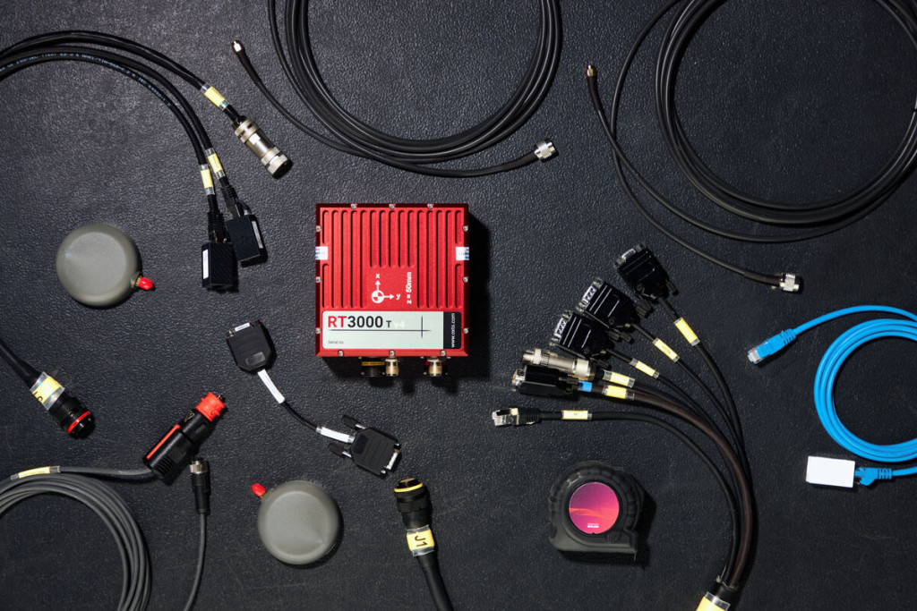
In this blog, we’re taking a look at our flagship GNSS/INS, the RT3000 v4. It’s the most accurate GNSS/INS we’ve ever made, and it’s ideal for high-precision mobile mapping projects where accuracy is essential.
How the RT3000 v4 delivers high-precision mobile mapping accuracy
The RT3000 v4 uses the most advanced technology to deliver a range of improvements over previous models such as the Survey+. Here are the key features of interest to mobile mappers:
Higher-grade IMU options
The RT3000 v4 uses IMU10 technology, our most advanced IMU technology to date. It delivers greater precision than our previous IMUs, giving you even more precise calculations around heading, position, and orientation – up to a 90% improvement over our previous models. In fact, for mappers this translates into less position drift over time, and more accurate maps.
Multi-sensor fusion support
Additional connectivity options, PTP/gPTP synchronisation, and our Generic Aiding Data Interface make it possible to integrate a wide variety of sensors into the RT3000 v4. Customers have already integrated wheel speed sensors, LiDAR, radar, and cameras into their devices – and we are actively working on new integrations all the time to boost our high-precision mobile mapping capabilities.
Multi-sensor fusion enables mobile mappers to get accurate data in environments they previously couldn’t, including under trees and in cities where GNSS signals are partially blocked, and even underground where there’s no GNSS at all. By feeding additional sensor data into the RT3000 v4’s navigation engine, it is possible to use that data to stabilise position drift in the absense of GNSS.
6x faster warmup
The RT3000 v4 can initialise in under three minutes – six times faster than older models. So you can spend less time driving around a car park to warm up, and more time surveying. Not only can you initialise in under a minute, you can do so with less dynamic movements than before.
Want to know how our customers are using the RT3000 v4 for high-precision mobile mapping – read our customer story
Benefits for mobile mapping
Protect accuracy for longer
When surveying hundreds of miles of roads, or hundreds of square kilometres of land from the air, position drift is one of your worst enemies. The RT3000 v4 has greatly reduced drift compared to previous models, meaning you can survey larger spaces and expect the same quality of data throughout.
Survey in more places than ever before
Multi-sensor fusion support means that you can integrate LiDAR, radar, cameras and other sensors to get accurate localisation data anywhere. Even underground, an integrated LiDAR can still give you centimetre-level accuracy. Best of all, using the RT3000 v4 as the centrepiece of your payload means that you can transition between environments with, and without GNSS, seamlessly.
Add more value
Ultimately, as a mobile mapper the quality of your final output is what determines your value to your customers – whether they are internal or external. The more precise your measurements, the greater their value. It’s important to remember though that not every project requires cm-level accuracy and we do have other more cost-effective options if accuracy is further down the priority list.
This is where OXTS customers often get a lot of value out of our georeferencing software, which makes it easy to combine LiDAR and GNSS/INS data while also improving the overall quality of the point cloud.
Learn more about OXTS Georeferencer

Integration with LiDAR and vision sensors
We’ve already touched on how the RT3000 v4 is able to integrate with additional sensors to improve robustness in challenging environments. Let’s take a closer look at how that works:
The GAD Interface
The Generic Aiding Data Interface is designed to translate data outputs from additional sensors into a format that an OXTS GNSS/INS can use. It is included as standard in the RT3000 v4, and gives developers a set of tools to build their own sensor integrations for high-precision mobile mapping.
To make things simpler for the less technically-minded out there, OXTS has also developed a number of integrations – known as boosts – for common sensors, including LiDAR.
LiDAR Boost
LiDAR Boost works with all major brands of automotive LiDAR. It has two functions: LiDAR inertial odometry (LIO) and LiDAR map matching. Map matching is a capability that is particularly useful for engineers looking to develop maps for autonomous navigation as it compares what the LiDAR sees with a pre-existing map, in real-time, to enable autonomous navigation. Naturally this isn’t really useful for high-precision mobile mapping, who are looking to create the map in the first place! LIO, however, is very useful.
LIO works by analysing a frame produced by the LiDAR. An algorithm identifies planes and edges, that indicate the presence of walls and corners, and then identifies those same planes and edges in subsequent LiDAR frames. By tracking the movement of those planes and edges between frames, the algorithm can calculate a variety of datapoints including angular momentum and speed. These are then passed to the GNSS/INS through the GAD Interface, and used to improve the accuracy of the final position data.
Camera-based odometry
Similarly to LiDAR, cameras can be used to produce odometry data that the RT3000 v4 can use to improve accuracy in GNSS-denied environments.
Camera odometry relies on either one or two cameras – if two cameras, they are positioned at converging angles on the vehicle, so that they can see the same objects but from slightly different positions. An algorithm then identifies objects in the image, and tracks their motion across successive frames captured by the camera. By analysing the movement of the objects in view, the camera can then provide odometry data for itself, which is converted by the OXTS GAD Interface into measurements that can be used by the RT3000 v4.
OXTS Georeferencer: the secret weapon for mobile mappers
Of course, the hardware you use to gather your data is only half of the story. Once you have gathered your survey and navigation data, you need to combine them to produce a final, georeferenced, output.
That’s why it’s worth coming back to our LiDAR georeferencing tool, OXTS Georeferencer. It makes it easy to take navigation data from your RT3000 v4 and combine it with your LiDAR data – just a few button clicks is all it takes. If you’re using the RT3000 v4 for high-precision mobile mapping, OXTS Georeferencer is a vital tool in your arsenal.
OXTS Georeferencer has an additional feature that makes it even more valuable – boresight calibration. Boresight calibration is a process that precisely aligns the coordinate frames of your GNSS/INS and your LiDAR, maximising the clarity of your final point cloud. You can even eliminate so-called double vision in your point cloud, where objects appear twice, with boresight calibration.
Discover the RT3000 v4 today
Hopefully this blog has shown you the potential of the RT3000 v4 for high-precision mobile mapping. If you’d like to learn more about the RT3000 v4, head over to our product page. If you’d like to learn more broadly about how OXTS can help you with mobile mapping, contact us here.
Download the RT3000 v4 Datasheet
Learn more about the specifications you can expect from our flagship inertial navigation system the RT3000 v4.


